Case Study 1
THE 21ST CENTURY PARADIGM FOR SUSTAINABLE COASTAL MANAGEMENT
Beach erosion – natural or induced by human activity??
New Zealand has a relatively recent history of coastal impacts induced by human activities, but these have seriously impaired natural dune integrity and resilience. An early NZ botanist reported his observations of natural dune buffer function and the likely consequences of the all-pervading and escalating degradation of formerly stable NZ dunes: “coastal dunes … form a natural defence to the land against the encroachment of the sea, and, their movement inland is a national concern … while yearly further destruction takes place, the evil … becoming more difficult to suppress”. (Dr L. Cockayne 1911). This was some 4 centuries after King Christian II became alarmed by comparable dune degradation issues in his native Denmark, consequently drafted the world’s first Sand Drift Act, in 1539.
Over recent years, the variety of untenably accepted human impacts have only amplified coastal hazards. Just one mitigation method has atttempted to work with - rather than battle forlornly against – natural coastal processes. The information below reveals the success of these works, with three typical cases from the Bay of Plenty region of NZ.
1. RESTORATION OF TAURANGA BEACHES: economically & sustainably reversing human-induced beach erosion
The Papamoa case – a compelling example of the active reversal of human-induced beach erosion.
The image following (below) is an extract from a report on BOP beach erosion, which revealed a damaging practice that was remarkably common throughout NZ at the time – mining sand directly from the beach-face. The ‘unforeseen’ consequences of this (and similar practices) that damaged natural dune function were completely calamitous – “The real effect of sand extraction activities has been to CAUSE EROSION of 40-60m.”
Earlier Dune Degradation Practices Recorded at Papamoa Domain in 1975 (beach sand-mining)
The following observations were all made in the above report by Healy:
- The volumes of sand extracted from the beach-face are massive – acknowledged to be “greater than 330,000m3 (330,000 cubic metres) from 1965-75”.
- “The real effect of sand extraction activities has been to cause erosion of 40-60m”.
- “… the indications are that the sand extraction rate … exceeds the capability of the system to replenish the sand naturally by littoral drift”.
This sand mining was located adjacent to and on the southern side of the present-day Papamoa Surf Lifesaving Club, as shown by the maritime pine trees (Pinus pinaster) of Papamoa Domain in the background of the above photo.
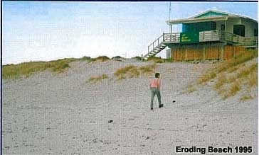
If this unwitting but nonetheless severely degrading activity had not been subsequently curtailed, the beach and dunes in this area would have continued their human-induced retreat inland. The surf club building (and possibly other infrastructure) would have consequently been seriously affected by this ill-informed removal of the dune buffer. The real impacts would have, at least, included storm surges eroding additional sand from around the surf club building. Fortunately sand extraction did cease soon after publishing the report; however the harm was done - the dunes remained in a damaged state through to 1995, when the photo below was taken. This photo reveals how the lack of protective vegetation (on the dune slope in front of the now precariously perched surf club), encouraged subsequent wind erosion of remaining sand (see the rocks under the timber panels below the deck on the building). This situation of continuing wind erosion prompted calls from some groups in the community for the surf club to be moved back to a safer location further inland, at a more secure distance from the ever-encroaching sea.
Papamoa Surf Club 1995
A new and novel methodology was needed here, one where simple restoration of these degraded dunes could be utilised - working with coastal processes rather than battling against these natural forces. And so after inclusive discussions with members of this Surf Club, a dune replanting plan was agreed. The plan involved planting of native dune plant species to stabilise the dynamic dune slope, and then to build fences for protection of the plants in this high-use area. The results of this inclusive, inexpensive and progressive work appear in the photo essay below:
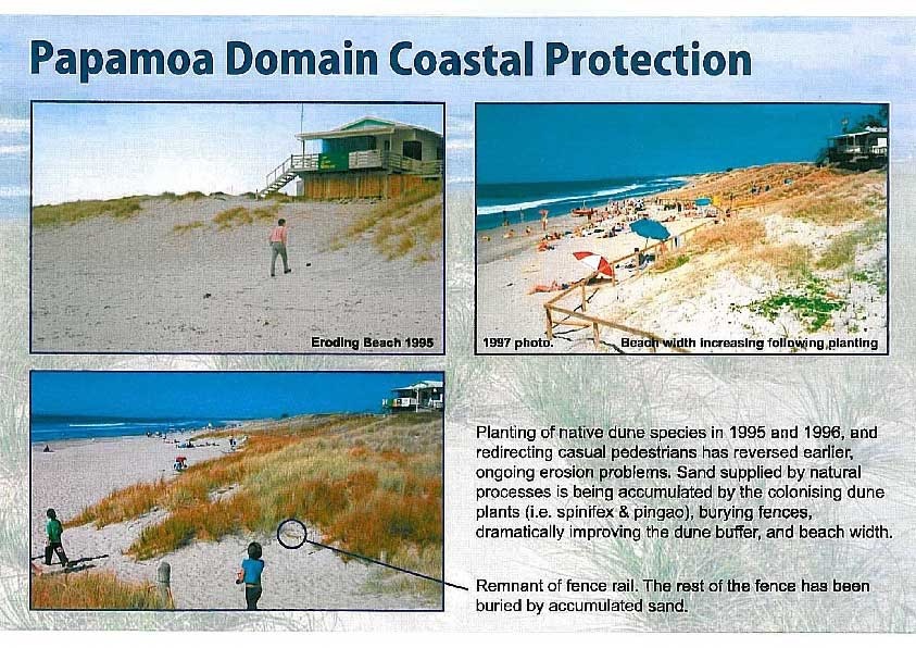
Note that only one community-involved planting occurred here – in 1996. The early proliferation of the pioneer dune plants is still being encouraged, to ensure natural colonisation of bare sand on the dune slope, by simply moving the protective fences in a seaward direction each 2-3 years. The plants consequently rebuild raised foredune profiles along their seaward edge, and so form the increasingly wide dunes and beaches seen in these photos. Timber fences were later replaced with the easier-to-move bollard and rope fences, which also are more sympathetic to the beach environment and have many other aesthetic & practical advantages as well.
The dune has moved seaward (or accreted) by more than 20 metres at this location, along with a similar increase in beach width (see photos above). This accretion rate of 1.3 metres of fresh sand per year is a full reversal of the continuing “40-60m” of erosion that existed when Prof. Healy assessed the prevailing beach condition back in 1977.
It may be concluded by some people that the 1977 beach condition was aggravated by the strong La Niña storms over that decade, but as the graphs presented later in this document show quite succinctly, La Niña conditions have been more severe in the post 2010 years than those recorded previously, yet we can observe the positive dune accretion response after restoration, compared to continual beach erosion before replanting, with or without the effects of La Niña.
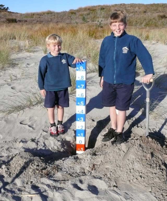
So while it was possible to evaluate the distance that dunes and beaches are moving seaward, we still did not possess a useful and simple measure of the vertical accumulation of the precious and increasingly protective sand resource – the cumulative height gains of these returning natural foredunes. To provide this missing link, the ‘Sand Datum Post’ was designed by the writer in 2008, and placed in various locations at the seaward edge of restored dunes in June of that year. The posts are striped in 10cm wide colour bands – alternating red & white (for below ground-level measurements after placement), and blue & white (for above ground-level measurements), and demonstrated in the photo below, with two happy helpers at the beach near Harrison’s Cut, Papamoa:
Placement of Sand Datum Post showing the easy-to-read 10cm increments, Harrison’s Cut, June 2008.
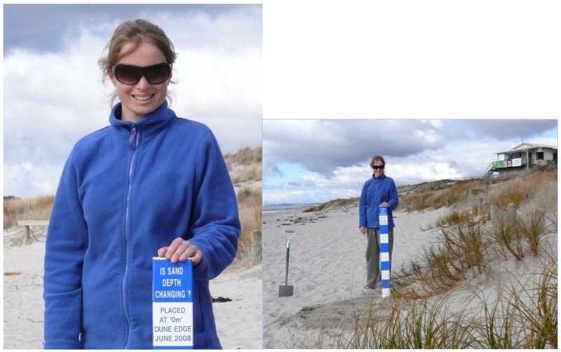
These datum posts were placed at several locations in June 2008, principally to measure sand accumulation (or erosion). They are all securely placed to ensure that no tampering occurs, and are designed for ease of use by both interested members of the community (using the easy-to-read increments), and for the more educational purposes of measuring accumulating (or eroding) beach sand volume.
The results from the Papamoa Surf Club measurements are shown in the photos below. Now we can observe how the dune and beach have responded by moving out towards the sea, largely due to the simple and economical restoration of these indigenous dune plants, the complete opposite to the situation observed by Prof. Healy in 1977:
Sand Datum Post placement at the dune toe and at the zero mark by Papamoa Surf Club – June 2008.
The dune was visited again in 2012, and the height of fresh sand accumulated by the restored dunes easily quantified, as shown in the photos below. It is profoundly significant that the strong onshore winds of La Niña storms now induce dune accretion, compared to the serious dune erosion commonly experienced previously.
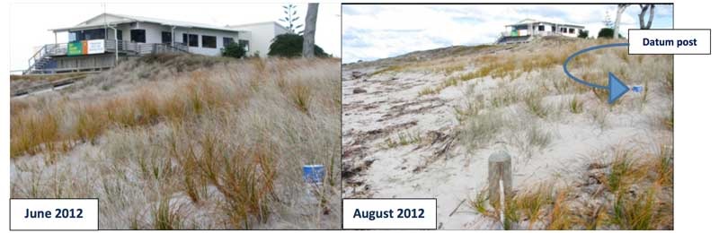
New sand to a depth of 80cm is shown in the left photo (above - June 2012), increasing to 90cm in the August photo (above right) after further La Niña-induced winter-period storms. The vegetated dune width (i.e. the new foredune) is now 20m seaward of the 1997 line, an average dune width improvement of 1.3metres/yr. This process has accumulated fresh and porous sand to a depth of 90cm (in the last 4 years), a sand accumulation (accretion) total of 18m3/m of beach thus far (or 18 m3/lineal metre of beach length by 2012). The increased porosity of sand accumulated on native dune plants encourages increased absorption of wave volume and lower water tables during storm surge run-up into foredunes (de Lange & Jenks 2007, Muller 2011). This increased porosity function is demonstrated by the 2012 photo which reveals the impact of a recent storm – simple addition of extra sand and further plant nutrient-supply courtesy of the beach-cast seaweed. A subsequent 2014 update reveals the above datum post is now completely buried by accreting sand and dune width has increased to >22m beyond the 1997 line, all owing to assiduous restoration of indigenous C4 halophyte dune plants and consequent improved natural function of this dune ecosystem. Dune volume increase is now >22m3/m of beach. NOTE: before restoration, La Niña storms invariably induced dune erosion, not the accretion effect revealed now.
The Harrison’s Cut case – another example of active reversal of human-induced beach erosion.
This man-made watercourse channel (‘the cut’) was carved through nearby dunes onto this beach to drain inland swamp areas, to increase the area of dry farming land back in the 1940’s (TCC pers. comm.) This action, along with the common practice of farming dunelands (and grazing the native dune plants), held no regard for the probable serious impacts on natural functions of dunes by this damaging action, especially when combined with the erosional effects of frequently flowing water. Consequently, beach levels were seriously reduced at this location, affecting a >100 metre length of beach on each of the north and south sides of the stream exit. This beach lowering now allows storm surges to roll ever-further inland, inducing beach and dune erosion. Periods of heavy rainfall naturally cause greatly increased water flows, higher water tables, and frequently coincide with wind-induced storm surges and strong north-east gales, which blows sand in a southerly direction along the beach. The storm surges add their own havoc, while strong winds cause large-scale sand movement that transports large volumes of sand into the upwind side of the watercourse, consequently inducing the stream channel to move increasingly in a southerly direction. This unnatural stream meander along the coast has encouraged further dune erosion over the long period since the 1940’s. In an attempt to halt this unnatural and damaging process, geotextile sand pillows were placed on the southern side of ‘the cut’, to prevent water flow from meandering and creating any fresh channels on this side.
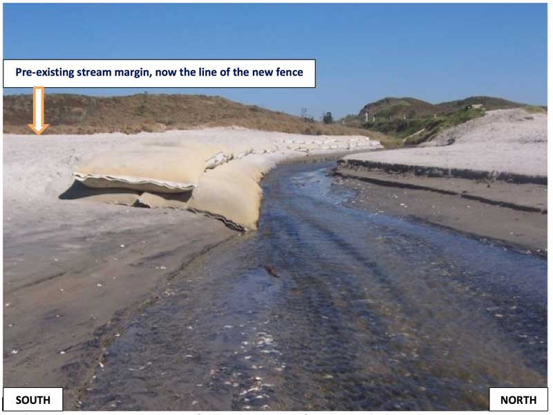
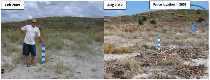
Harrison’s Cut - bare sand on the south side (left side of photo) is now safe from ‘stream’ intrusion, so this bare sand was restored by replanting (and fencing) native foredune species in 2005. Sand colonisation by these plants was very rapid, and therefore a Sand Datum Post was later installed to quantify changes due to this re-colonisation (see photo below).
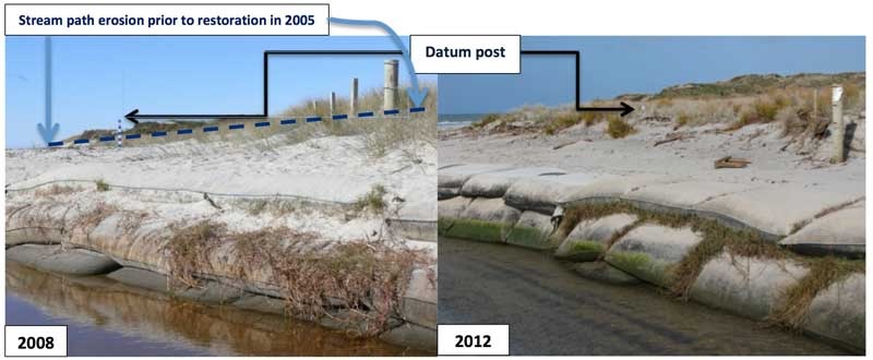
The below photo on the left side was taken in 2008, just after installation of the sand datum post, and reveals the rapid growth rate of the new AND indigenous dune plants. The fence on the right side of this 2008 photo (below) was the seaward boundary of the planting which had occurred just 3 years prior – in 2005. The plants can easily be observed realising the goal of accumulating and stabilising substantial fresh sand amongst their runners (or stolons) colonising all the available wind-blown sand on this beach. The plants are now progressively producing functionally restored dunes. Note - the fence shown below is (in August 2012) nearly completely buried by the sheer volume of this newly accumulated sand.
The 2012 photo on the right (below) reveals the volume of sand that has accumulated following restoration works in this degraded area. The dune area seaward of the datum post has now refashioned a raised beach profile and increased width of the dune, helping to reverse some of the impacts of this very unnatural watercourse, cut to the coast over 70 years ago. Even the natural impacts of strong La Niña conditions have not severely hindered progress.
Harrison’s Cut: This watercourse initiated beach erosion of the area landward of the right-side of the fence above. Geotextile bags were placed by beach restorers to direct water flow away from this damaging path, and so permit sand to accumulate. This process was aided by restoration of native salt-tolerant dune plants. Even with the strong La Niña impacts over the past 4 years, dune and beach width (and height) is slowly improving, with an extra 20 metres of functionally protective and porous sand dune seaward of the datum post in the 2012 update photo.
Harrison’s Cut: The left photo (above) reveals 20cm of vertical sand accretion only 8 months after datum post placement; the right photo shows this has now increased to 40cm, or an increase of 20cm over 3 years at this site, even with the previously severe human-induced impacts (see the debris from winter La Niña storms in 2012). This progress with dune and beach function is slow but on-going, and shows no indication of changing or decreasing.
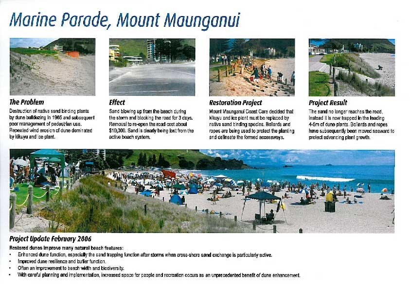
The Mt. Maunganui Case – yet another example of active reversal of human-induced beach erosion.
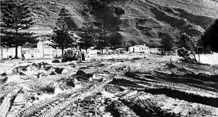
Mt. Maunganui beach endures an additional example of human mismanagement of a formerly perfectly functional natural ecosystem. The ecosystem services (including welcome protection from storm surges & some tsunami, wide sandy beaches for recreation and swimming) that were provided free to residents of (the former) Mt. Maunganui Borough, were totally ignored and wholly undervalued, and as a result these dunes were simply bulldozed aside to make room for car parks and ‘more formal’ recreational areas, and subsequently planted with invasive kikuyu grass.
Mt Maunganui: beach dunes during ‘improvement’ operations by bulldozer and motor-scraper - 1965.
The harmful effects of damaging mechanical destruction of dunes AND attendant natural dune function was to be endured by this community for more than 35 years, until rehabilitation of dune processes could commence, in 2001.
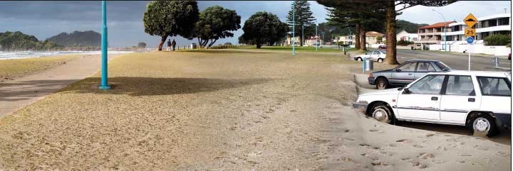
A typical onshore-storm photo of the ‘day after’ – sand blown up and lost from the beach system, wastefully covering kikuyu lawns, blocking roads, impacting on parked cars and buildings across the road.
But after restoration of indigenous pioneer dune plants was initiated in 2001, the colonising plants so utilised have flourished (as has been experienced everywhere else now) and reversed the former and problematic dune erosion problems into a return of natural, very economical and increasingly favourable coastline accretion processes.
Below is another photo essay of the procedures utilised to achieve this reversal and hence the long-desired natural results. Please take particular notice of the photo below titled “The Problem” as this was the barren and frequently eroding state of dunes in this premium residential and holiday area, with sand regularly being blown inland and lost from the active and functional ‘beach compartment’:
The length of this degraded dune (see The Problem photo, above) was planted in 2001 by members of the wider Tauranga City community, and on only one occasion. All the new plant growth has subsequently proliferated purely through natural colonisation of bare sand through the naturally vigorous growth of long stolons (runners) from the two main native plant species – spinifex and pingao – plus physical movement of the fences on a regular basis, ever-seaward to accommodate this sprawling new growth. Interestingly, beach width is also increasing naturally at a similar rate to the growth of dune width, so these restored beaches are not being dominated by this burgeoning plant growth, but conversely are increasingly available for recreation AND restoration of natural beach ecosystems.
NOTE: “TripAdvisor announced the winners of its Travellers' Choice Awards for top beaches” on 18 February, 2015. “The awards recognise the best beaches globally. In New Zealand, Mount Maunganui beach topped the list for the third year in a row and took out second place in the South Pacific Top 10 Beaches list.” (Source: Bay of Plenty Times)
This award would have been doubtful if the beach had stayed as in “The Problem” photo above, and this further reveals that coastal ecosystem restoration has many advantages, even enhancement of tourism opportunities.
Measuring the rate of dune expansion:
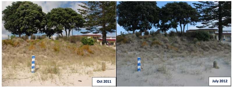
The left photo (above) reveals 35cm of vertical sand accretion 3 years after datum post placement; the right photo shows this has increased to 50cm, or an increase of 15cm in just one (stormy) year at this Marine Parade location. These improvements to dune and beach function are on-going, and show no indication of changing or decreasing.
The beaches discussed in these photo essays above are all located in the Bay of Plenty region of New Zealand, and were all suitable for restoration by positive community action, and cover a total distance along the coast of 12 km.
Other beaches with restored dunes in the wider Bay of Plenty region, and successfully restored beaches outside this region, all exhibit similar improvements to natural sand accretion and dune function, regardless of location and climatic conditions, on both east and west coast plus existing North and South Island sites. This response is universal.
Climatic Conditions: La Niña – El Niño/Southern Oscillation Index (SOI) over the last four decades:
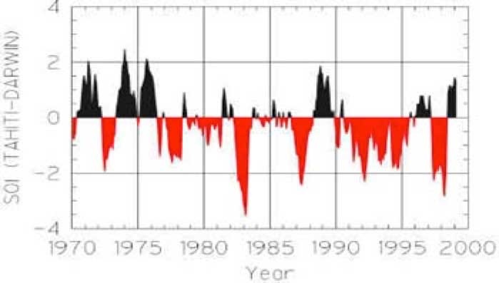
Early La Niña – El Niño /Southern Oscillation Index: 1970 – 2000 (Supplied by NIWA)
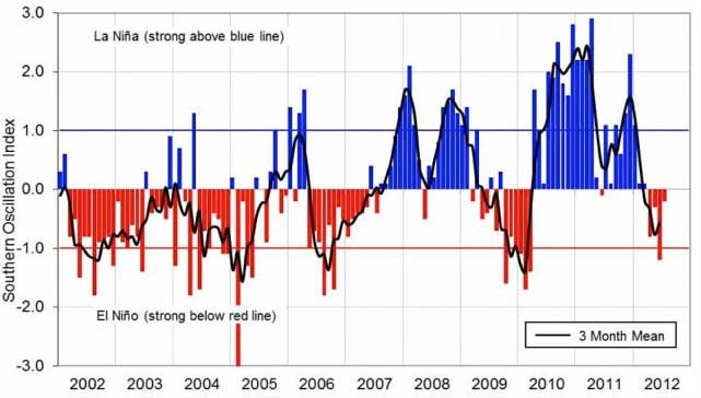
Latest La Niña - El Niño/Southern Oscillation Index data: updated August 2012 (Supplied by NIWA)
This climate data indicates that La Niña conditions have been problematic for 6 out of the previous 15 years of local dune restoration activities, while 4 of the recent 5 years have been particularly strong with SOI readings almost reaching three-month means of 2.5 (>1 on the SOI scale is rated as ‘strong’), a situation that would normally induce conditions that favour serious coastal erosion. This expectation is due to elevated levels of oceanic storms and storm surges with low atmospheric pressures affecting these east coast localities, plus persistent and occasionally severe onshore winds. That was certainly the situation when similar La Niña conditions persisted 4 decades ago, in the 1973-76 period. Back then, that series of La Niña storms caused beach erosion (to beaches previously degraded by human impacts) so serious that many damaging and expensive seawalls were built around this nation (e.g. at Waihi, Ohiwa, Omaha and Raumati Beaches). Please note: some beaches are currently not suitable for restoration works, due to a variety of reasons, usually involving unsustainable impacts (like houses placed inappropriately close to the coast, or lack of sensible setback regulations, presence of seawalls or revetments, the large degree of poorly controlled anthropogenic erosion etc.).
But there are many suitable beaches currently realising the benefits of community-involved restoration of coastal processes (using this natural, economical and sustainable manner), increasingly accumulating sand while being pleasurable and enjoyed by all, with the results endorsed by whole communities. People are observing and cherishing many improving natural attributes, like the much superior recreational and aesthetic values, increasing beach and dune width, plus the other benefits of improved stability (e.g. less sand blowing inland), improving dune ecology, plus provision of FREE and enhanced ecosystem services (like protection from the concerns of on-going dune erosion, some protection from the early effects of sea level rise, and enhanced coastal property safety etc.).
Using the sand volume accumulation rate at the Papamoa Domain site (22m3/m of beach) and averaging this over the 22km of continually accreting beaches from Mt. Maunganui to Papamoa East, this indicates that nearly 500,000 m3 of fresh sand has been accumulated and stabilised by the indigenous pioneer dune plants since their restoration commenced 15 years ago. Importantly, restoration of dune ecology is occurring in tandem with this progress. And this reversal occurred while conditions often favoured the opposite - beach erosion. It should be no surprise then that Tauranga City Council formally increased the width of their 22km length of coastal reserves by 11m in July 2009.
The 4th Assessment Report of the IPCC cited the low cost of this protective restoration work in 2007 (just 1% of the most common alternative), and so justifiable support is increasing for utilising these proven and successful coastal restoration practices as a first-line technique for coastal communities to adapt to the early impacts of existing sea level rise. Data collected at the site of the Papamoa Surf Club by the Sand Datum Post placed at the dune toe and at the zero mark in June 2008 reveals the following information:
ASSIDUOUS DUNE RESTORATION – PAPAMOA BEACH ECOSYSTEM RESPONSE: 1996 to JUNE 2014
| ESTABLISHMENT DATES | DUNE DEPTH CHANGES to 2014 | DUNE WIDTH CHANGES to 2014 | DUNE VOLUME CHANGES to 2014 | CHANGES PER ANNUM |
|---|---|---|---|---|
| 1996 Planting: once only - as natural plant colonisation & proliferation ensued | 1996 – assessed as zero | +30metres (m) wide and continuing | Was not quantified originally – suitable instruments were not initially available | Dune width growth +1.3m/year. This rate of gain continues |
| 2008 Datum Posts added, to quantify changes in sand depth + dune width, i.e. dune volume changes | 2008-2014: sand accretion 1.0m depth (recorded after 2008 datum post placement) | +12m seaward of the original datum post location, and still improving | >22m3/lineal m of beach following the original planting, this gain continues | Dune volume growth +1.8m3/year/lineal metre of beach, and this rate of gain continues |
Data collected from the above and other associated sites around NZ have provided the following findings about preparing for the impacts of sea level rise (SLR), and published for the ESRI Users Conference in San Diego 2015:
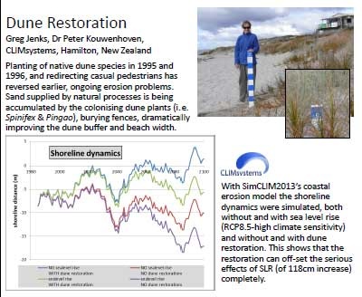
The CLIMsystems ESRI Poster above plainly states that this case study provides increased confidence that restoration of coastal ecosystems will not only reverse previous anthropogenic impacts, but also “can off-set the serious effects of SLR (of 118cm increase) completely.”
These projects discussed above have all employed community-led principles that have been proven to succeed in ‘The Innovative 21st Century Paradigm for Sustainable Coastal Management’, and so have finally permitted the following to occur after centuries of unnatural degradational impacts that have consequently created relict dunes:
- The Restoration of Tauranga Beaches through active reversal of human-induced beach erosion.
- Have induced the return of continuing landscapes from the former, degraded cultural landscapes
- Have provided the best means available for restoration of threatened coastal biodiversity
- Have produced the pre-eminent successful and least-cost option for dealing with the impacts of SLR
Other publications of the restoration benefits accruing from many other successful NZ sites are being prepared.
Following-on from considerable research, all the data suggests that restoration work of this nature can and should be utilised at many other impacted and suitable coastal sites in New Zealand and even utilised in some global locations.
One simple question remains: why aren’t we utilising these proven, economical and sustainable solutions to reverse the many untenably accepted anthropogenic impacts on other degraded beaches in New Zealand?
Greg Jenks MNZM
Coastal Restoration Specialist
Mob: +64 22 1564 335
Email: greg@igci.org.nz
Foundation Member International Global Change Institute
WEB: http://igci.org.nz/
ClimSystems Associate
WEB: http://www.climsystems.com/