Risk Informed Decision Support (RIDS) System
RIDS Technical development strategies
System dynamics platform
The RIDS platform was built on the system dynamics simulation library “Sage,” from Highpoint Software Systems. Sage is a state of the art simulation engine, with powerful simulation capabilities and great flexibility in simulation architecture, control, construction and integration. Built on Microsoft’s industry standard .NET technology, RIDS also uses Windows Presentation Foundation (WPF) technology to implement a friendly, flexible and extensible GUI.
The RIDS architecture was designed to provide robust support for three classes of users – Developers, Modellers and Analysts/PolicyMakers. Developers are able to reach into the deepest software layers to extend existing, or build new, simulation, modelling and interactive capabilities that integrate seamlessly with (essentially becoming part of) the RIDS application. Modellers are able to use blocks and connectors, user interaction and model aggregation capabilities to create robust models, and Analysts and Policy Makers use simple and powerful analytical tools that smoothly integrate models and other decision making tools into a decision support engine for formulating practical approaches to real world challenges. Therefore, the RIDS core can act as a generic platform for many other areas other than climate change issues by adding outer components.
The RIDS platform was designed to support layered applications. The central layer of the system provides the fundamental scientific understanding of climate change and related issues, the graphical user interface (GUI) and the model development environment. The interactive layer allows efficient and effective interaction between the model developer and end user. The policy making layer supports policy making processes by providing outputs in a variety of formats, such as graphs, maps, and technical information. RIDS supports a participatory assessment approach through users’ dialogue with urban policy makers and planners from targeted cities.
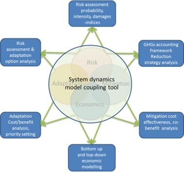
A unique advantage of applying a system dynamics approach is the ease with which one can extend and revise models as the domain is explored and questions arise. RIDS will allow in-flight alteration of models and their data and presentations, the use of a visual coupling tool for data conversion, and dynamic updating of workflows. A set of climate change impact models (flood, storm surge, heat waves and others as identified during the current project), economic models and multiple criteria decision analysis tools will be developed and incorporated into RIDS. The flexibility of the system will be augmented by establishing standard model and data libraries that provide the building blocks for a wide range of related applications.
The building up of RIDS database
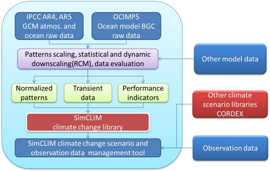
RIDS has, and will maintain, a comprehensive climate change assessment database which includes up-to-date IPCC GCM, and RCM data for climate change scenarios. These data have been adapted from SimCLIM and other international and national climate change related datasets directly or using various downscaling methodologies. RIDS will also be able to incorporate other emerging datasets such as AR5 and the new RCPs scenarios. User defined scenario and empirical data also could be included into the RIDS database if users so desired. It is our expectation that the RIDS database would be organically grown by its user communities and coordinated by ADB and its partners. From a technology perspective, we are considering basing a central repository on an open source system called ‘Subversion.” Integrated into RIDS, it would enable people to use the data, models and tools from the central repository, but also to non-destructively overlay that content with their own local variants for exploratory, transient or what-if analysis. This allows the ADB to control data such that an “official study” must use sanctioned models and data, while giving individual organizations the freedom to use their own where appropriate.
RIDS model library development strategies
To help realize a publicly accessible and broadly useful library, this project proposes to cooperatively develop an extended urban climate change decision support model library, potentially to include models tailored to climate change impact and risk assessment for the other major analytical sectors: climate related hazards resilience, water, transport, and health. We would involve urban policy makers and planners from targeted Asian cities as a part of this cooperative approach. Many models have already been created for these sectors, although most of them are standalone, or too specific for broader use. Through the RIDS Community of Practice, these models and tools can be enhanced and integrated into a standard platform, enabling robust knowledge and technology sharing and transfer.
During the proof of concept stage, a number of climate change analyses, decision support tools and models have been identified and prioritized for strategic integration into the RIDS platform.
Some models and tools have been demonstrated to our stakeholders in China and Vietnam, including a climate change scenario generator, a sea level rise scenario generator, a sea level rise impact model including damage and cost-benefit analysis model, and a decision tree and multiple criteria decision analysis tool. A number of existing models also were identified which can be integrated with RIDS, including extreme event analysis, heat stress modelling, and water resources management tools.
RIDS navigator building
The RIDS navigator presents models and studies in an informational setting. Each model and study is presented alongside documentation that explains its use, applicability, limitations, and genesis. A user can dynamically create a new study or project, add documentation and models, and optionally export it for general use, including importing it into a community knowledge base.
The RIDS navigator is intended to:
- Enable decision makers and planners to be more productive, more comprehensive and more correct in a shorter period of time by providing a friendly browser-like environment that speeds the learning curve.
- Provide a common repository for data, models and tools, thereby encouraging active cross-pollination of disparate knowledge, reuse of appropriate models and leveraging of analytical tools across a range of analytical domains.
During the proof of concept stage, we have built up an illustrative set of models and documentation in the RIDS knowledge base, including documentation and models for the case study cities, Guangzhou, China and Rach Gia, Vietnam. These documents and models should be viewed -- as is the RIDS tool itself -- as a proof-of concept, and as an impetus for further discussion as to the utility of such a knowledge management approach.
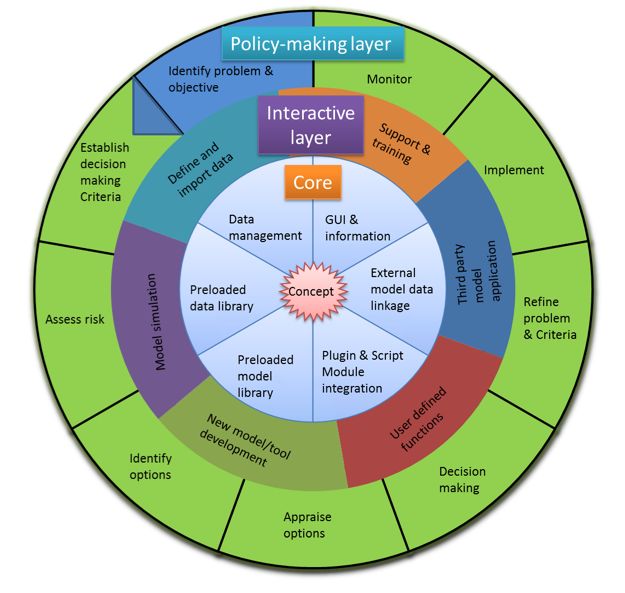
The core components of the tool
| Core 1: Data management |
This tool allows the drag-and-drop function which means users can drag the customized data or models to the working window, and the data and model can work immediately after the drop (copy). Data management tools enable the import and export of the climate, land and socio-economic data, in time series (monthly, daily, hourly, sub-hourly) or spatial patterns (ARC-GIS grids, and polygon layers, for example). The site data manager, data import wizard, and data browser functions all permit the user to freely import site specific or gridded data into the system. An area browser allows users to view and edit all the data available in the system. Import & export link to other formats for third party software. |
| Core 2: Preloaded data |
All the functions, data and models are linked to the climate change scenarios. This tool provides the basic climate change scenarios at the global level, and can also provide customized local scenarios according to the case study area and users’ requirements. GCM data, RCM, SD data, historical observation data High level background GIS data, shapefiles, population, DEM, river basin, etc. |
| Core 3: Preloaded models |
Models developed from previous work are preloaded into the system for application Generic models: such as, water balance model, extreme values analysis, drought index (SimCLIM modules) and others can be developed or linked Health impact model (need to be calibrated before application) |
| Core 4: Model integration tools |
System dynamics approach. Dynamic-Link Library (DLL): new models or function can be developed as DLLs in a certain convention; they can then be dropped into the system and applied. Script: type in equations, simple models on screen and carry out the analysis |
| Core 5: External model/data linkage |
Provide data exchange protocol for the models and the tool can be linked to the toolkit. |
| Core 6: GUI & Information (Help) |
Geographical information systems files: shape file, gridded file Graph: Excel, Access, database Note: user can type their notes and save to working items Help & Key message |
Interactive layer major functions
| IL1: Define and import data |
Data availability checking, define the baseline data, spatial resolution, master plan or projection future time line. Import the required data for model simulation: including: climatic, geophysical, socio-economic, geospatial data Geographical information systems files: shape file, gridded file Graph: Excel, Access, database |
| IL2: Model simulation—output |
Parameter setting, run models, result checking, graphing, layout Parameter setting Climate scenario; socio-economic develop-scenario; adaption and/or mitigation option selection, input, cost estimate Economic analysis method (cost/benefit, cost effectiveness, co-benefit) Target setting Run models, result checking, graphing, layout |
| IL3: New model/ tool development |
No suitable model is available in the model library, discuss with the related developer for new model development through in-depth research. |
| IL4: Model coupling and development Tool |
System Dynamics Methodology Plugin DLL (screen shot), define functions through script functions Existing models can be re developed as DLL using a certain convention then plug into the tool for application. Simple equations/ relationship can be typed on the tool interface and to carry out analysis. One of the unique advantages of using system dynamics models to study public policy issues or problems is that they can easily be extended or revised to address additional questions as they arise. The tool allows users to register different models, input and output of the model, use a visual coupling tool for data conversion, define workflows, run workflows, and monitor workflows. The tool will deploy dynamic data conversion techniques for the user-created data mapping schemas using the provided visual tool. |
| IL5: Link to third party models through linkage functions |
Complicated models or heavy computing consuming models which are not suitable to be directly run in the tool, a linkage function would perturb the model input data with climate change projection. |
| IL6: Technical support and training |
It is essential for an appropriate application of the tools. The embedded complexity and uncertainty of climate change information may not be well understood without training or good technical support. Link to project feasibility study tools and finance instruments and guidance. |
Resilience
Resilience has been defined as "the ability to prepare and plan for, absorb, recover from, and more successfully adapt to adverse events." The term resilience is applied to a range of topics including physical security, business continuity, emergency planning, hazard mitigation, and the built environment’s (e.g., facilities, transportation systems, and utilities) ability to resist and rapidly recover from disruptive events. This paper focuses on research needs for achieving community resilience of the built environment. Community resilience depends upon the capacity of facilities and infrastructure systems to maintain acceptable levels of functionality during and after disruptive events and to recover full functionality within a specified period of time. Natural, technological, and human-made hazards in the United States continue to be responsible for significant losses and damage to the built environment. To improve the disaster resilience of communities to hazard events, each community needs to develop plans based on a risk-informed methodology that addresses multiple hazards, system performance levels, recovery of functionality, and dependencies between systems. However, quantitative tools and metrics and risk-informed guidance for communities are not presently available.
Resilience has been defined as "the ability to prepare and plan for, absorb, recover from, and more successfully adapt to adverse events." The term resilience is applied to a range of topics including physical security, business continuity, emergency planning, hazard mitigation, and the built environment’s (e.g., facilities, transportation systems, and utilities) ability to resist and rapidly recover from disruptive events. This paper focuses on research needs for achieving community resilience of the built environment. Community resilience depends upon the capacity of facilities and infrastructure systems to maintain acceptable levels of functionality during and after disruptive events and to recover full functionality within a specified period of time. Natural, technological, and human-made hazards in the United States continue to be responsible for significant losses and damage to the built environment. To improve the disaster resilience of communities to hazard events, each community needs to develop plans based on a risk-informed methodology that addresses multiple hazards, system performance levels, recovery of functionality, and dependencies between systems. However, quantitative tools and metrics and risk-informed guidance for communities are not presently available.
Risk assessments
Risk assessments are usually commissioned and conducted as part of a risk management and adaptation plan. Assessments usually start with the hazard to identify potential damage scenarios and probabilities and model potential consequences over time and space.
Risk management, on the other hand, encompasses a larger domain and is based on many considerations that are not part of the assessment results. These considerations are explored in detail through a case study analysis in this paper. It is, however, important to recognise that, in the design and application of risk assessments, they do not automatically translate into a set of recommendations or plan of action to be taken up by decisionmakers. This ‘uptake’ needs to be carefully considered within the disaster risk management or climate change adaptation plan.
Using risk assessments in decision-making
Risk assessments are important as both products and processes. They can provide valuable inputs to decisions that need to be taken about where to invest or what to insure, and they can also raise awareness among stakeholders about different components of risk. Conducting a risk assessment can increase transparency and it can even be used as a consensus-building tool.
The role of disaster risk assessments may be analysed from a number of different, but complementary, decision-making perspectives:
- Increase awareness and understanding of disaster risk, thus laying the ground for more attention to be paid to disaster risk management and climate change adaptation.
- Develop financial applications to spread and transfer risk to the private sector (such as insurance).
- Guide and inform risk management and adaptation policies and investments at different levels based on decisions about acceptable levels of risk (e.g. for engineers to design construction projects).
- Inform early warning systems and contingency planning in the development of preparedness and emergency response plans.
- Inform land-use, urban and spatial planning decisions. Previous studies suggest that risk assessments need to be targeted to specific needs and decisions, at different scales and sectors. For example, a risk assessment conducted with the purpose of engaging communities, communicating risk and promoting local action will have low data requirements and costs compared to an assessment needed to inform risk management policies in a city, or for catalysing growth in the catastrophe risk insurance market.
Scenario Planning and Its Application
Scenario planning is a comprehensive exercise that involves the development of scenarios that capture a range of plausible future conditions. That development is then followed by an assessment of the potential effects of those scenarios on a focal resource or decision, and the identification of responses under each scenario, with a focus on those that are robust across scenarios. Whereas predictions and forecasts are statements about what will happen in the future with some degree of certainty, scenarios are plausible, alternative characterizations of the future not intended to be associated with probabilities. Scenarios can be constructed as qualitative narrative storylines or quantitative expressions of future conditions, depending on the outcomes needed to achieve the goal of the planning effort. While there are a variety of ways to use scenarios in planning, this guide focuses specifically on the use of multiple future scenarios to embrace uncertainties in decision making as a means for managing risk and maintaining flexibility in current and future decisions.
Scenario planning is particularly appropriate in complex situations where uncertainties about future conditions and the effectiveness of management actions are uncontrollable and irreducible. This can be the case when elements of socio-ecological systems that provide the context for natural resource management have the potential to greatly influence decision outcomes. These elements, or drivers of change are external to the resource and beyond the direct control of managers (e.g., environmental factors, population growth and demographic changes, land use patterns, the availability of financial resources, etc.). Uncertainties that cannot be reduced within a decision timeframe because they are beyond managerial control or outside current scientific knowledge make it difficult or even impossible to develop informative predictive models. Scenario planning offers an alternative approach to considering future conditions as uncertainties and the level of complexity of a situation increases, the longer one looks into the future, and when there is a relatively low level of understanding about the issue.
Scenario planning has received increased attention as a tool to inform natural resource management decisions in light of climate change. Climate change uncertainties range from gaps in our understanding of how climate systems function; whether and how much humans reduce or increase greenhouse gas emissions; what the rate, direction and magnitude of climate changes might be; how natural and human systems may respond to those climate changes; and what will constitute effective management actions in light of those changes. There are also uncertainties surrounding how climate change will interact with other social, economic, political, and technological changes.
Scenario planning is just one method to support planning and decision making under uncertainty, and it can be used in complementary ways with other decision frameworks, methods and tools, such as adaptive management, structured decision making, and iterative risk management. It can be used to serve multiple purposes, including education and outreach, decision support, and research. While there are key steps in the process, there is no single established methodology for conducting scenario planning, or even discreet types of scenario planning approaches. It is a method that can be tailored to meet a wide variety of needs and available time, capacity, and financial resources.
General Principles and Benefits of Scenario Planning
Scenario planning is appropriate to use in situations of high uncertainty and low controllability, to examine different future trajectories and anticipate surprises
Scenario planning explores plausible—not always the most probable—futures
- Identifies key drivers of future change and the underlying assumptions to provide greater transparency
- Assumes that future boundary conditions are not necessarily the same as those that currently influence a system
- Builds awareness of multiple pathways toward the future
Scenario planning is underpinned by strategic thinking on how decisions of today limit future options
- Facilitates a move away from traditional single-outcome planning
- Allows the exploration of plausible future developments of potential importance to current and future decision-making
- Challenges thinking on current management actions
Scenario planning is not a “one size fits all” approach; there are multiple ways to design a scenario planning exercise
- Combines qualitative and quantitative information to describe changes to future environmental conditions
- Synthesizes and integrates issues across sectors and scales in a common framework
- Fosters consistency in characterizing future conditions across diverse studies, spanning different sectors, regions and scales of analysis, to enable direct inter-comparison of results
- Provides a common logic to integrate key drivers of change, as well as their impacts and interactions
- Outcomes may be very technical (e.g., computer simulation), as well as creative, depending on project need
Scenario planning facilitates participatory learning and understanding
- Fosters improved learning and imagination
- Can help participants collaboratively create a narrative or storyline
- Moves away from a single dominant perspective toward acceptance of unfamiliar but valuable ideas
- Can help create powerful stories to share with stakeholders outside of the planning process
Scenario planning is a living process, requiring us to revisit key plausible futures to validate, replace, or remove them as we gain knowledge
- Embeds a future-oriented perspective into organizational and individual thinking and operations
Key Questions to Address when Considering an Adaptation Strategy
1. What is the goal of the adaptation strategy?
In the case of floods, for example, it is possible to:
a. Maintain the current level of risk
b. Reduce the level of risk despite climate change (if the risk is considered too high)
c. Limit the increase in the level of risk due to climate change
In the case of agriculture, for example, an adaptation strategy could:
a. Aim to maintain the current type and level of production (e.g., through irrigation)
b. Promote a transition to other crops, for example, ones that require less rainfall
Once the goals have been decided, efficiency criteria can be set for use in the review process.
2. Does the adaptation strategy take into account the varied timeframe over which climate hazards occur?
a. “Adaptation gaps” (i.e., what needs to be done regardless of climate change) are immediate-term needs to ensure that the sub-national territory has adapted to the current climate (for example drainage systems that are adequate to cope with the current level of precipitation)
b. Adaptation options that can be operationalized in the short-to medium-term: for example, plans to adapt to phenomena such as heat waves and droughts that will occur in the immediate- to medium-term
c. Adaptation options that are needed in the context of managing issues that are likely to be problematic in the future, over different time scales— the next 5, 10, 15, 20, 30, 50 years and so on. For example, new urbanization plans to adapt to gradual sea level rise or industry developments in the context of likely decreasing viability of the effectiveness/productiveness of specific sectors as the climate changes
3. Is the adaptation strategy a no-regret/low-regret solution?
(This means one that yields immediate benefits even in the absence of climate change)
More efficient and effective water management, for example, may lead to cost reductions/savings and health benefits that promote a developmental improvement for the sub-national territory, regardless of climate change.
Consideration must be given to all the unintended and likely unintended consequences of such strategies, including cross-sectoral implications. Promoting the use of air-conditioning, on the other hand, is not a no-regret/low-regret solution, as its use requires more intensive energy use, which in turn contributes to climate change.
4. Is the adaptation strategy flexible and reversible?
This is important given the uncertainty inherent in projecting future climate change – if parameters turn out to be different from what is currently projected, will it be possible to adjust the strategy accordingly?
The strategy and measures must be robust to a range of potential climate change scenarios.
5. Consistency with other sub-national territory goals?
Sub-national planners in particular will be aware of the plethora of planning and developmental goals in their area. It is important to ensure that the adaptation strategy is consistent with other goals over the short, medium and long timescale. For example, does adaptation option have a positive or negative impact on poverty reduction?
Does it fit into the short term planning goal for the sub-national territory?
Does it fit in with nationally-promoted sustainable development strategies?
Risk governance
Risk governance deals with the identification, assessment, management and communication of risks in a broad context. It includes the totality of actors, rules, conventions, processes and mechanisms and is concerned with how relevant risk information is collected, analysed and communicated, and how management decisions are taken. It applies the principles of good governance that include transparency, effectiveness and efficiency, accountability, strategic focus, sustainability, equity and fairness, respect for the rule of law and the need for the chosen solution to be politically and legally feasible as well as ethically and publicly acceptable. Risk accompanies change. It is a permanent and important part of life and the willingness and capacity to take and accept risk is crucial for achieving economic development and introducing new technologies. Many risks, and in particular those arising from emerging technologies, are accompanied by potential benefits and opportunities. The challenge of better risk governance lies here: to enable societies to benefit from change while minimising the negative consequences of the associated risks.
Sound risk governance minimises:
- Inequitable distribution of risks and benefits between countries, organisations and social groups
- Differing approaches to assessing and managing the same risk
- Excessive focus on high profile risks, to the neglect of higher probability but lower profile risks
- Inadequate consideration of risk trade-offs
- Failure to understand secondary effects and linkages between issues
- Cost of inefficient regulations
- Decisions that take inappropriate account of public perception
- Loss of public trust
IRGC’s risk governance framework is a comprehensive approach to help understand, analyse and manage important risk issues for which there are deficits in risk governance structures and processes. The framework comprises five linked phases:
- Pre-assessment
- Appraisal
- Characterisation and evaluation
- Management
- Communication
These interlinked phases, which are summarized in the following pages, together provide a means to gain a thorough understanding of a risk and to develop options for dealing with it.
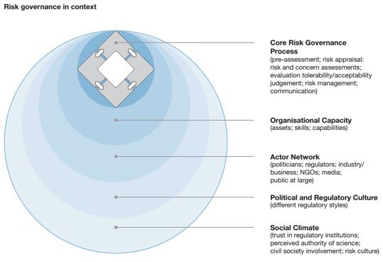
Alongside the conventional elements of risk assessment, risk management, and risk communication, the framework stresses the broader social, institutional, political and economic contexts that must be taken into account in risk-related decision-making.
Risk communication
Risk communication is a fundamental element of a sound risk management framework. Notification of the public about major hazards and threats, to which they may be exposed, should be a basic responsibility of governments. Increasing the awareness of households, businesses and communities about their hazard exposures and vulnerabilities, as well as the specific measures they could take to prevent, mitigate or prepare for them is the essence of risk communication. Such information spurs informed debate on the need for investments in prevention, mitigation and preparedness, and is thus a key element of good governance in risk management policy.
Some survey evidence suggests that more could be done across EU and OECD countries to raise risk awareness through better risk communication. For example, the results of a survey of 1 700 companies in the Loire river basin in France showed that 53% of the business owners whose activity was located in a flood zone admitted to being completely unaware of their exposure (OECD, 2010). Low levels of awareness about existing hazards and the responsibility to take protective measures are endemic to low levels of resilience, meaning the capacity and speed of regaining function after a disruption.
Ineffective risk communication can lead the public either to underestimate risks, which may result in taking insufficient precautionary measures, or to overestimate risks, which often leads to suboptimal allocation of resources. Despite concerted government actions to raise and maintain awareness of hazards and threats, there are significant divergences between experts’ understanding of risks and the general public’s perception of risks. Few countries find that risk communication efforts fully achieve their desired objectives, yet many countries continue to use the same techniques that have failed them in past, in the hope that the target audience will pay more attention. There is value and opportunity, therefore, to identify novel practices and techniques of effective risk communication practices across similarly situated countries and to test hypotheses for policy transfer.
EU as well as OECD Recommendations make risk communication a key priority for improving future risk management. The EU Council Conclusions from 13-14 December 2011 on risk, emergency and crisis communication emphasises the need for risk communication to enable citizens to recognise risks and take subsequent actions that reduce their potential exposure. The Recommendation recognises the importance of interaction and coordination among public authorities, international organisations, NGOs, citizens, the media, businesses and citizens’ associations, including trade unions, to make risk communication effective. Finally, the Conclusions acknowledge the usefulness and importance of new communication technologies and interactive information channels such as social media as instruments to be considered in risk communication strategies, taking into account cultural, social, linguistic, economic, risk and technical conditions in different countries and localities.
The OECD Council Recommendation on Governance of Critical Risks recommends “a whole-of-society approach to risk communication and facilitate transboundary co-operation using risk registries, media and other public communications on critical risks” and proposes a two-way communication between government and stakeholders, combining targeted communication with the provision of incentives and tools for stakeholders to invest in resilience measures.
The Third recommendation sets out a set of criteria for effective risk communication:
- Consistency: it is fundamental to ensure that risk information is consistent across the different risk communication tools. Inconsistencies in this domain can lead to ineffective policies, lack of trust and inaction.
- Two-ways communication: risk communication should not be seen as only transmitting expert knowledge to the public. More interactive approaches bring together the public with risk managers to engage in an exchange of risk information. It allows inter alia to engage more actively the stakeholders in risk reduction efforts, to collect more broad information about risks and to evaluate the efficiency of risk communication tools through feedback loops.
- Accuracy and trust: risk communication should be based on the best available knowledge on hazards, threats and vulnerabilities. Full transparency about the level of accuracy is necessary to ensure that risk information is trusted and acted upon.
- Accessibility: while risk communication supposes dedicated and targeted actions, citizens and business should also be provided with easy-to-use and accessible risk information portals and repositories.
- Adaptation to audience: dedicated risk communication should target specific segments of society, from national to local levels, vulnerable groups, children and elderly, communities, and non-residents (e.g., tourists) in ways that are adapted to both their cognitive capacities and their specific exposure or vulnerabilities.
- Cross-sectoral and transboundary: risk communication should incorporate information from different sectors so that the public has a clear picture of the multiple dimensions of potential hazards and threats, and their potential cascading effects. Consistency across regional and/or national borders to communicate about risks should also be addressed; both for cross-border hazards and also to ensure that investors, travellers, tourists and other stakeholders can understand risk information in other countries.
Risk Informed Decision Framework (RIDF) planning process as follows:
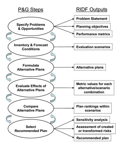
1. Specify Problems and Opportunities:
Frame the decision by developing a problem statement and identifying the spatial and temporal boundaries of analysis (i.e. planning area and planning units).
Establish planning objectives and choose outcome measures of performance, or metrics, which reflect progress toward achieving the planning objectives.
2. Inventory and Forecast Conditions:
Select models of physical and economic systems or other appropriate tools to simulate decision outcomes in terms of the selected performance metrics. Identify important sources of uncertainty in physical and economic models.
3. Formulate Alternative Plans:
Formulate decision alternatives by identifying potential measures for flood risk reduction, pre-screening poor performing measures, and formulating an array of alternatives planning unit from remaining measures.
4. Evaluate Effects of Alternative Plans:
Model the outcome measures of performance for each alternative and each scenario.
5. Compare Alternative Plans:
- Obtain weights on metrics from the decision makers and/or stakeholder groups.
- Calculate multi-attribute utility and implement the stakeholder preference analysis for each alternative and scenario.
- Identify consistently dominating plans in each planning unit based on the multi-attribute utility values.
- Develop alternative ranking of plans based on assessment of evaluation criteria addressing other decision objectives viewed as important to decision makers.
- Conduct an indexed scoring of alternatives based on the MCDA results and alternative plan rankings.
- Identify the final array of alternatives for each planning unit and prepare detailed tradeoff analysis of plan performance and outputs for these alternatives.
- Apply secondary evaluation criteria and sensitivity analysis (e.g., varying levels of participation in nonstructural measures and analysis of alternatives under degraded coastal conditions).
- Screen out plans that are consistently dominated.
6. Select a Recommended Plan:
- Develop strategies for combining top performing alternatives in each planning unit to create comprehensive plans.
- Develop conclusions and findings based on the above analyses.